
Harrison County Sources for a Property Block
A neighbor lookup in Harrison County stitches together two kinds of data: where a parcel sits and who holds the account. The GIS map supplies the geometry. The Assessor ties a name to each tax parcel. The statewide assessment search returns address-based results, while the County Clerk's plat and deed records explain lot lines. No buffer or select-adjacent tool exists here. The map user simply notes each nearby ID and works through them one at a time.
| Source | What it shows nearby | How to use it |
|---|---|---|
| County GIS Tax Parcel Viewer | Parcel outlines and map context | Select the subject and note bordering IDs |
| WV Assessment Search | Owner and parcel results by street or ID | Search each nearby account |
| Recorded plat | Lot, block, and subdivision layout | Check whether map parcels touch on the plat |
| County Clerk deed index | Recorded descriptions, easements, and rights-of-way | Read the instrument when a line or access right matters |
The Harrison County GIS hub links a Tax Parcel Viewer and a 911 Addressing Locator. Its Assessor ArcGIS service carries layers for Parcels, LandHooks, Right Of Ways, Old Boundary Line, Districts, DistMap, TIF Districts, and IASData. The Identify tool can inspect any selected feature. No official tool calculates every touching parcel automatically. The layer list does that work by hand.
Start with parcels. Turn to the other layers only when they help. They matter when they explain a road, a district, or a historic edge.
The layer view comes from the Harrison County Assessor map service.
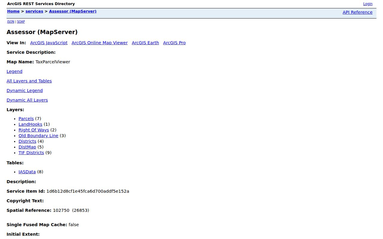
Use the layer view to gather likely adjacent IDs, then confirm each one in the Assessor. The WV Property Viewer help page documents the identify and parcel-selection behavior.
Select the subject parcel first; nearby IDs still need individual lookup and boundary confirmation.
Identify Adjacent Harrison County Parcels
Find the subject parcel by physical address or parcel ID. Zoom until its outline is sharp, then select it. Write down every parcel ID that seems to share an edge. Note any that share a road or a common boundary too. Open each of those IDs in the Assessor or statewide assessment search. Compare the owner name and legal description. Be careful here. A map view can make two parcels look like neighbors. A road, right-of-way, or narrow gap may actually divide them.
The statewide viewer draws parcel edges at roughly 1:18,056 scale. A click that selects nothing usually means you should zoom in farther. Stacked parcels can open a list of IDs instead of one. The viewer's first display uses the physical address. A selected parcel may show a separate mailing address. Keep each field tied to its account. That way a mailing address never gets mistaken for the property next door.
- Find the subject parcel and write down its district, map, parcel, and suffix.
- Zoom in and use Identify or a map click to note nearby parcel IDs.
- Check each ID in the Assessor or WV Assessment Search.
- Compare the map with a plat or deed when a shared line matters.
- Record the date and source for each neighbor result.
The Harrison County parcel-map page walks through the map layers and the parcel key. The focus here stays on the properties around one chosen parcel rather than the full GIS guide.
Note: Map proximity suggests a nearby account, but it does not prove two legal parcels share a line.
Harrison County Street Parcel Results
The WV Assessment Search includes a Street Name field. The local Assessor Ownership Search lacks this field. The local tool focuses on owner and parcel components instead. A street query lists accounts along a road. It helps build a block-level set. When filters exist, narrow by county, district, parcel, or property class. Street-name results carry quirks, though. They may skip a private drive. They may use an abbreviation. They may also group addresses differently than the map does.
Work from each result's parcel ID, never from its position in the list. The Harrison County GIS can confirm whether a returned parcel truly sits near the subject. A street search is not a census of every adjoining parcel. Nearby roads can change what neighbor means for a specific property question. So can cross streets, hidden parcels, and boundary lines.
Check Harrison County Parcel Plats
A plat shows subdivision lots, blocks, and access paths that a tax map alone hides. The Harrison County Clerk's index lists large and small plats, a plat cabinet, survey books, road records, and district land books. Search by subdivision, party, book, or parcel clue, then read the drawing and its notes. Exact plat book and page references for local neighborhood names are not published in the index.
Historic labels in Clarksburg include downtown, Stealey, North View, Glen Falls, Adamston, and Quality Hill. Those names help orient a map search. They are not necessarily recorded subdivision names. The plat or deed supplies the legal reference. In Bridgeport, Simpson district appears in the land-book list, though a district name alone does not place a parcel inside city limits.
When a line affects access, a fence, or a sale, rely on the recorded plat or survey and consult a licensed surveyor. A GIS outline exists for tax and reference work. It can point you to the right file. It cannot settle a disputed lot corner.
Harrison County Property Address Clues
A Harrison County owner record often carries two addresses. One is the situs, the physical spot where the parcel sits. The other is a mailing address, which is simply where the tax bill travels. The statewide viewer leads with the situs. Click the parcel and the mailing address may appear. A trust, estate, or company can complicate things further by listing yet another contact point. Treat the mailing address as a clue, never proof of where someone actually lives. It cannot replace the parcel map or the deed records behind the account.
Keep three fields in separate columns as you work: situs, mailing address, and legal description. The situs finds the building. The mailing address traces the notice route on the tax roll. The legal description ties everything back to the deed or plat. Sometimes a street-name match and your map selection disagree. Then compare parcel numbers. Ask the Assessor which account the property truly belongs to.
- Adjacent
- Near or next to a parcel; map proximity alone does not prove a shared legal line.
- Abutting
- Sharing a boundary, subject to the deed, plat, and survey.
- Buffer
- A GIS operation that selects features within a set distance; no dedicated Harrison tool was verified.
- Parcel ID
- The county tax-map account key used to look up each lot.
Note: Keep each mailing address separate from the situs and legal description in every Harrison County neighbor note.
Harrison County Parcels Cross City Lines
Permit records in Bridgeport can explain a new structure or address sitting near another parcel. The city's floodplain code requires permits and site plans. These apply to development and to substantial improvements. Copies of those permits also reach the County Assessor. Requests for a new-structure address go through county E-911 instead. Bridgeport keeps its floodplain files permanently in a hazard-safe location. So an assessment address sometimes lags behind construction. A researcher looking at nearby parcels then has another official source to consult.
Still, remember that city permitting and county ownership remain separate worlds. County GIS and the Assessor define the land. They also set its tax accounts. Bridgeport governs its own zoning and permit rules. An old Simpson district book label may help with vintage records. It does not map city limits, though. Confirm the parcel's true location before questioning the city about a neighboring permit.
Limits on Harrison County Neighbor Records
A neighbor list offers public parcel clues and nothing more. It cannot tell you who lives inside a home. An account can be missed entirely. An owner of record may be outdated. Or the mailing address may sit far from the land. A tax map, meanwhile, proves nothing about a surveyed line shared by two parcels. When a boundary or easement is disputed, the Clerk's deed and plat records come first. Then a licensed surveyor can settle an exact line.
Put adjacent parcel data to lawful uses: property diligence, civic planning, and understanding recorded boundaries. Never use it to stalk, harass, or target a neighbor. Disputes belong with the right public office or a qualified professional. Contacting someone over an uncertain map click is not the way to settle one.
No dedicated buffer tool was confirmed. Harrison County’s verified route is to select parcels, record their IDs, and look each account up separately.
Verify Each Harrison County Parcel
For every nearby account, log the parcel ID and owner field. Add the mailing address, situs, and search date in one place. A search result with no deed reference should send you to the County Clerk index. Search it by name, by role, or by legal description. City questions need the municipal permit office for that same parcel. This routine keeps a tax neighbor, a mapped neighbor, and a legal adjoining owner from blurring together, so each one stays distinct in your notes.
Be aware that the owner field can lag behind a recorded deed. GIS lines can also generalize a boundary. Compare sources before trusting either one. A Harrison County neighbor lookup deserves a verified record route as its ending. An assumption built on a nearby label does not qualify. An unreviewed map boundary does not qualify either.
Note: Record the parcel ID and search date so another reader can retrace the Harrison County lookup.