
Run a Harrison County Property Search
Start with the tax parcel. That is the fastest route from a known street address to a real record. Harrison County's local Ownership Search runs on owner names and parcel components, with no street field anywhere in the form. A street clue fits the statewide WV Assessment Search or the GIS hub better. When a result appears, copy the parcel key and legal description before opening another site, a habit that keeps a nearby parcel or a near-identical owner out of your notes. Use this order whenever the parcel is unknown.
Search the street name statewide. Pick the likely match. Compare its situs address with the map. The record may also show a mailing address. That is where tax notices go. Carry the parcel ID to the local assessor form and the County Clerk's deed index; use the Harrison County parcel map after the account is identified, while deed history stays in the Clerk's index.
- Search the address or street name in WV Assessment Search and select Harrison County.
- Compare the situs address and legal description to the property you mean.
- Record district, map, parcel, suffix, owner name, and any deed book/page reference.
- Check the local Assessor form by owner name or parcel, then open the GIS parcel.
- Use the Clerk index if the goal is a transfer, deed copy, lien, plat, or prior owner.
Harrison County Owner Search Fields
The Assessor's Ownership Search takes two owner-name inputs plus a surface parcel search and a mineral account search. Names go last name first. Case does not matter. A percent sign works as a wildcard. The surface path splits the number into district, map, parcel, and suffix, while the mineral path uses a district and map/parcel format with no spaces, so a mineral interest may hide from an ordinary surface search.
| Local field | Entry form | Search note |
|---|---|---|
| Owner name | Two text boxes | Last name first; case-insensitive; use % as wildcard |
| District | Dropdown | Pairs with surface or mineral account |
| Surface parcel | Map, parcel, suffix | Example format: 03 18017100000000 |
| Mineral map/parcel | Text without spaces | Separate account; example 99990123456780000 |
Searching the form costs nothing. The Assessor office at 229 S. Third Street in Clarksburg lists 304-624-8510 on the Ownership Search page. Hours run Monday through Friday, 8 a.m. to 4 p.m. Real estate, minerals, homestead, and tax questions each go to different staff, so call the division that matches the account. A front-desk search will not settle a legal interest.
The Ownership Search page lays out each field plainly. District, map, parcel, and suffix get separate boxes, not one generic APN field. That suits a search by a known parcel number.
View the original Harrison County Assessor Ownership Search to compare the owner and parcel fields.
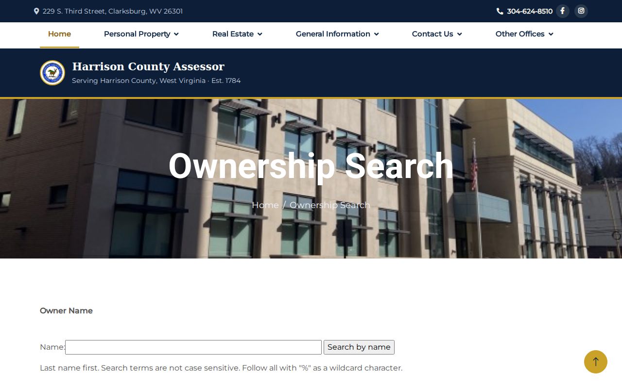
Pair these fields with the parcel key from the matching assessment record, not with a street address. If the surface search fails, try a wildcard spelling. The account may be mineral instead. A formatted parcel in the wrong fields returns nothing. Protect leading zeroes. Match every component against the assessment or map result before deciding the account is absent.
Note: Keep each parcel component and any leading zeroes intact when moving from the Assessor form to GIS.
Street Name and Statewide Search Modes
The WV Assessment Search fills the gap the local form leaves. Modes include Basic, Appraisal/Sales, Advanced, and Prior Ownership. Street Name works as a text search. County, district, and parcel filters narrow it. The tool also takes Full Parcel ID, Map Number, Parcel, Sub-Parcel, mailing address, legal description, and deed book/page. Date and price ranges trim appraisal or sales results.
Building filters cover year, area, and structure type. Other options handle property class, tax class, land use, flood hazard, acreage, and ranges for land, building, total appraisal, or sale price. Filters narrow a search. They promise no filled fields. A missing value can reflect the source roll or an unreturned record, not a bad query.
The statewide assessment search returns a match count, a query URL, a Property Viewer link, and CSV output. Use the local form for owner and mineral options. Turn statewide for address, sale, or building filters.
| Statewide field | Entry type | Required | Search use |
|---|---|---|---|
| County | Dropdown | Optional | Limit a statewide query to Harrison County |
| Street Name | Text | Optional | Search a road name |
| Full Parcel ID / Map / Parcel / Sub-Parcel | Text | Optional | Carry the tax-map key into the form |
| Property Class / Tax Class / Land Use | Dropdowns | Optional | Narrow by account classification |
| Sale From / Through | Date fields | Optional | Limit appraisal and sales by date |
| Land / Building / Total appraisal | Min/max numbers | Optional | Filter assessed components |
| Sale price | Min/max numbers | Optional | Filter sales by price range |
| Calculated / deeded acres | Min/max numbers | Optional | Compare acreage ranges |
| Flood Hazard | Dropdown | Optional | Apply the available flood filter |
| Mailing Address | Text | Optional | Search the tax-notice address |
| Deed Book / Page | Text pair | Optional | Cross-reference a recorded instrument |
| Legal Description | Text | Optional | Search lot/block or metes-and-bounds text |
| Building year / area / structures | Numeric ranges | Optional | Filter improvement details |
| Display legal description / GIS parcel ID | Checkboxes | Optional | Choose result details |
| Lines per page | Number | Optional | Set the result-page length |
The WV Assessment Search powers these statewide modes and filters.
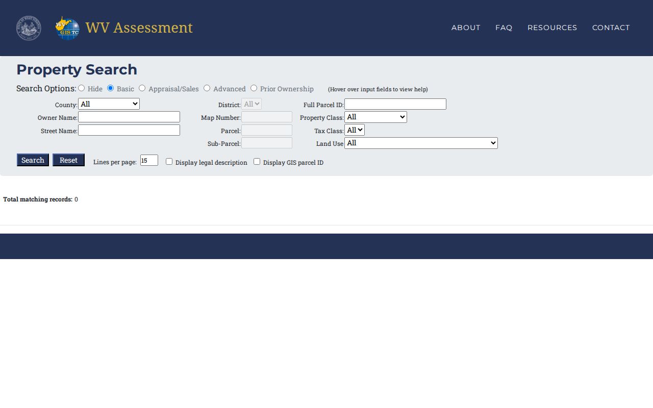
Filters narrow the field; the parcel and legal description still need a match.
Read the Harrison County Parcel Key
A Harrison County parcel key splits into district, map, parcel, and suffix. Read each part separately. The statewide form labels the same pieces Full Parcel ID, Map Number, Parcel, and Sub-Parcel. Never strip a leading zero. A neighboring county's number may follow a different layout entirely. The parcel key is the sturdiest bridge between the Assessor and GIS. The Clerk's deed index, though, may still want a name or instrument search.
Address text is shakier. A street name can be abbreviated, renumbered, or entered with a directional prefix. One assessor account may show a physical situs. The tax bill, meanwhile, may travel to a mailing address. The statewide viewer lists the physical address first. Click the parcel to see the mailing address. It may sit in a different town from the land itself.
Harrison County's GIS hub includes a separate 911 Addressing Locator. For a new structure, especially in Bridgeport, E-911 and permit records may offer a clue. That clue can come before the address appears in a street search. Move from address to parcel. Never take a mailing city as proof of jurisdiction.
What a Harrison County Search Result Returns
A Harrison County search result works as a compact index into the fuller tax and land records. Fields vary by mode and parcel. Expect owner of record, situs, mailing address, parcel or GIS ID, legal description, district components, class, acreage, structure details, appraisal amounts, flood hazard, and deed book/page. Not every card fills every field. Check the portal's own result shape before trusting a missing value. The result is a pointer, not the record itself.
| Owner name | The name tied to the assessment account; it may be an entity or estate. |
|---|---|
| Address | Physical location and, separately, the address used for notices. |
| Parcel and legal description | Tax-map key and land text to carry into GIS or the Clerk index. |
| Land, building, total | Assessment figures, not an offer price or licensed appraisal. |
| Sale/deed details | Search filters or book/page clues when those fields are available. |
Save the portal's output with your search date. Harrison County publishes no confirmed assessor refresh schedule. A deed recorded last week can still be newer than the owner string on a tax card. Treat a result list as a lead. When the name is important, compare it against the recorded instrument itself.
Note: A search result may omit fields that are not populated or not returned by the selected mode.
Separate Harrison County Mineral Accounts
Surface land and mineral accounts follow different search paths in the local Assessor form. Searching the visible surface parcel will not always find the mineral account. Oil, gas, and mineral questions may need the district, a compact map/parcel string, and a second owner-name pair. Note the result type. The account format itself flags a non-surface parcel.
The Assessor lists oil, gas, and minerals at 304-624-8523. If an index hit concerns a mineral deed, release, lease, or right-of-way, read the legal description and the interest conveyed. A name match proves little, because the record may have moved the surface, a royalty, or a limited subsurface right. Read the recorded document for the legal effect.
Names deserve the same caution. An estate, trustee, LLC, or life tenant can appear in one system under a form that differs from the deed. Search entity names and individual variants alike. Sort same-name hits by parcel description. Do not merge accounts because the street or surname looks familiar.
Harrison County Situs and Mailing Addresses
Situs means the physical place of the land or building. A mailing address is where the tax notice goes. That split explains why a map pin and an owner's correspondence address differ. It also explains a mailing city that ignores the municipal boundary. The WV viewer shows the physical address first. Parcel detail may reveal the separate mailing address.
Use an address as a finder. Then verify the parcel ID, legal description, and district on the map. In Bridgeport, a city permit for a new structure is copied to the Assessor, and new-address requests run through county E-911. Shinnston's code regulates address-number size and placement. These records can resolve a new or changed address, but they never turn ZIP or mailing geography into a legal boundary.
- Situs address
- The physical location associated with the parcel or structure.
- Mailing address
- The destination for assessment and tax notices.
- Legal description
- The lot, block, or metes-and-bounds text used in recorded instruments.
- Parcel ID
- The county’s tax-map account key, separated into local components.
When a Harrison County Search Misses
A blank result is not proof that no record exists. Try the surname with a percent wildcard first. Then check a possible mineral account. Try a different street spelling too. Make sure the parcel components sit in the right fields. For deed work, lean on the Clerk's grantor and grantee roles. Those name assignments drive the index. For tax status, ask the Sheriff's office for its live tax-search route rather than guessing at field names. The delinquency screen and exact tax fields are best confirmed with that office directly.
The Harrison County Clerk sits at 229 S. Third Street in Clarksburg. The phone number is 304-624-8674, and the counter keeps posted weekday hours. The county site posts a land-record inquiry link plus a fee schedule. The index may hide an older book or an image. In that case, request it by name, book, date range, and instrument type. A West Virginia FOIA request also works. It must describe the public record specifically. Reproduction at actual cost is allowed.
A fuller property history can draw on plat cabinets, survey books, local directories, or Waldomore. Still, the Clerk's recorded instrument remains the legal source for any transfer. Keep the search result, the book and page, and the deed image clearly separate in your notes. That discipline lets a later title review retrace every step you took.
Note: If a result comes back blank, try another name form and search the parcel description before deciding the record is missing.